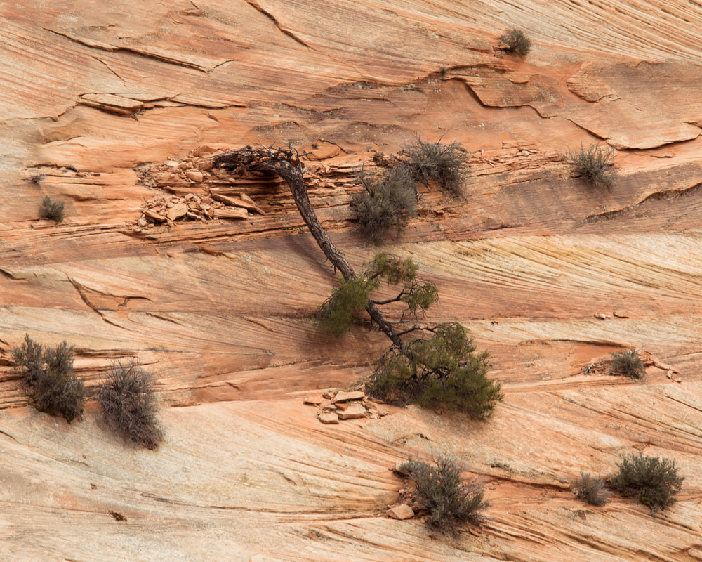
  The canyon before us looms large and narrow as we drive into the back of it. The sandstone walls have patterns of lines which cut in different directions every five to ten vertical feet. Zion has a unique beauty where the golden and red sandstone cliffs make the greenery pop. We are briefly cutting through three of the five national parks in Utah on our way to Canyonlands. The first is Zion, whose beauty is surprising and varied. We leave the massive canyon via a 1.1 mile tunnel dug in the 1920’s which finally gave people a way to pass through the canyon, rather than making the long detour around. We come out the other side to an entirely different view. The scrub and trees are just a hint less green and instead of sheer cliffs around us, there are large, steep hills of sandstone with that characteristic patterning of lines cut at a diagonal running through everything. Millions of years ago this was a vast desert covered in sand dunes. As time passed, the dunes grew and were eventually buried themselves. The lines we see today are the various layers of sand built up by the dunes. When the lines change directions, it is another dune being blown on top of the first one. Around a corner, we see a group of people ogling up a sharp hill and we stop to see what they are looking at. The most adorable young mountain goats peak out from behind a log, weary of the visitors. We spend some time snapping photos and watching them. On the other side of the road, at the bottom of this steep slope, is the rest of the herd, munching away at the grass that survives down there. We exit Zion National Park and drive across some of the last mapped parts of the continental U.S. Zipping through Bryce Canyon, we gaze upon the land of the Escalante-Staircase National Monument. More high cliffs and fascinating sandstone formations. We make camp not too far from the highway, a stretch of road which finally connected this remote part of the country to the rest in the 1930’s. Our spot is surrounded by the beautiful red dirt and juniper trees. If we had more time we would stay here for a few days. 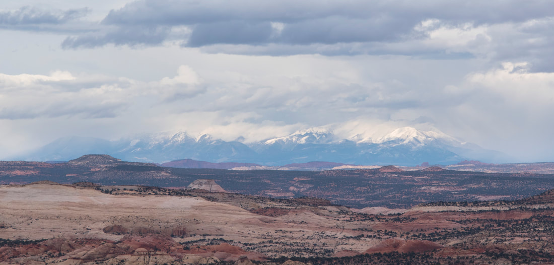
 We pass by Boulder, Utah in the morning. This small town of 226 people claims to be the last community in the continental US to receive its mail by mule train. Highway 12 was finished in 1939, finally connecting this portion of the country to the rest of the road system. Much of this area was some of the last land in the continental U.S. to be mapped. Surrounded by large mountain ranges and impassible canyons, this harsh desert made for difficult exploration. We climb over some of these last mapped mountains, taking in the panoramic views of southern Utah. We can see for ourselves now the large walls of mountains that border us. The red sandstone reaches far into the distance where water has surely cut deep gorges into it. Pines cover the mountains until the snowcaps glare white in the sun. This is a place of wild beauty and extremes.   Capitol Reef marks our third National Park in Utah and we fly right on through, going just slow enough to take in the rugged landscape and stopping briefly. Dating to somewhere between 10,000 and 300 years ago (nobody can seem to give us a clear answer on it) the people who roamed the desert southwest left behind markings on the sandstone walls. Here we stop to admire the handiwork of a people who no longer live here. Elk and mountain goats along with other strange glyphs and symbols cover a portion low on the sandstone cliff. Unfortunately, the European descendants who navigated this land, from the early explorers to today, have decided to leave their own marks. Awed by the past and annoyed by the present, we quickly make our way through the canyons and cliffs of Capitol Reef. Moab is on another planet. Tall cliffs of red sandstone border us to the west of the highway while massive mountains, their top halves still covered in snow, set the border to the east. Nestled into a wide canyon is the city of Moab. A total tourist destination, the place is bustling with jeeps, pickup trucks, and rv’s of all kinds. We meet Gavin and Liz at their hotel and go out for some food. After some tasty pizza, we make our way to bed, ready for the coming adventure.
 Into the park we go. The priority this morning is finding a campsite, so we beeline best we can for the campground to snag a spot before they all fill up. Luckily, we find one with relative ease. We set up base camp and go out to explore the park. Canyonlands is where the Green River meets with the Colorado River. Broken into three sections, we are staying in the Island in the Sky portion of the park. Here, a large plateau looks out over the canyons and spires dug out by the two rivers. We make our way from overlook to overlook, marveling at the grand scale of everything. Far below rage the rivers, barely seen. A hard white limestone extends far out from the base of the cliffs on which we stand only to be cut by the rivers into new canyons. Down there on the white rim, we can see jeeps trundling along as they navigate the dusty desert. We peer underneath the only arch in the park, looking towards the La Sal Mountains out to the east and the Needles district of the park down on the canyon floor. Not far from our camp is an overlook to the Green River. It meanders out there, not caring about the stone very much which impedes its way. 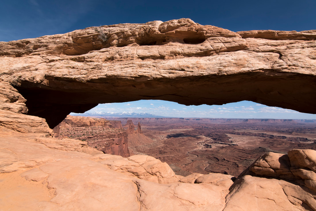 It’s enjoyable to meet with friends again. It helps me to feel more grounded here. That we are not alone out in the big world, and that we do have people who care and are interested in our lives. 
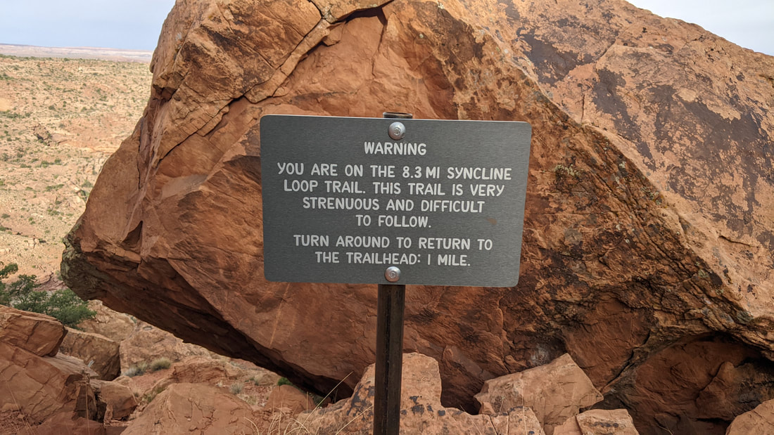 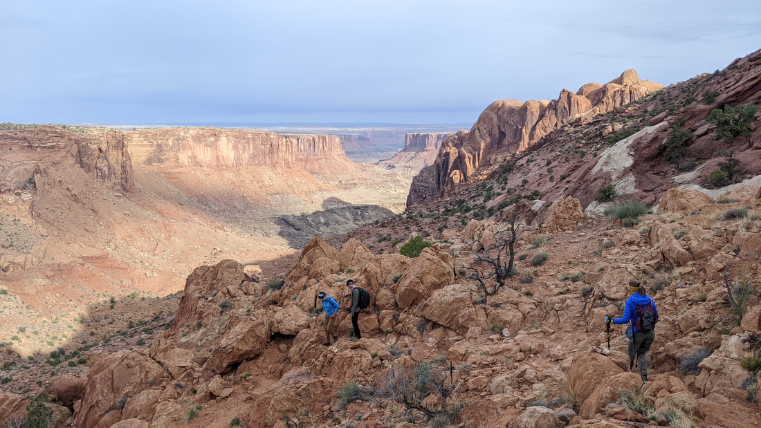  The sun is up but barely over the ridge of Upheaval Dome as we begin our descent 1,600 feet almost straight down to the canyon below. Around us, the red and black wall of the sandstone rises higher and higher, bearing down on us like some mystic beings, older than we can comprehend. The view down is dizzying but with each step the wash at the bottom gets closer as we traverse the steep decline. At the bottom, we meet a lone hiker. We’ve had a few people pass us on the way down, but he is the first to meet us going the other way around. He says he camped out on the White Rim Road last night and is doing the eight mile hike before heading out to the Needles. We wish him well and are on our way. In the wash, we proceed on a much flatter hike, walking with ease through the small canyons cut by water that must, at some time, rush through here. The sand and the walls around us vary from red to pale grays. We meet our second hiker going the other way. The ranger is loaded with a pack that almost looks as big as her. We chat and she asks if we have seen a single hiker going this way. We say we have and she gives a wry smile “He’s camping illegally, but he probably doesn’t know the rules.” With well wishes, we each go our own way again. 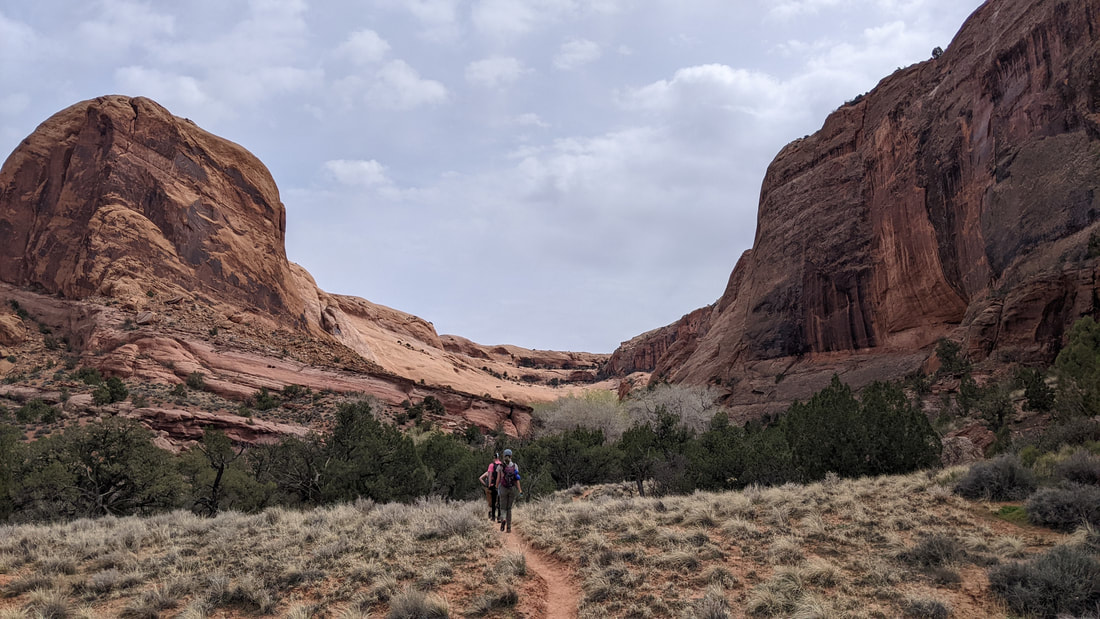  Our path takes us to an entrance inside the crater we have been circumnavigating. We all long to go forward that way, to see what might be inside the bowl that we have been walking around. But to add an extra three miles onto a hard eight mile day is a little more than we are all prepared for. Or at least, more than Lily and I are prepared for. A snack break here looking at the gap in the cliffs and then onward we go, continuing our circumnavigation. The trail leads us to a small oasis where large cottonwoods grow in the wash and we spy small pools of water as we climb higher. At the top of the oasis is a boulder field. Large blocks of sandstone are piled high on top of one another on a steep slope. Here, there is no nice strip of dirt that has been pounded down to help us find our way. The barren boulders are only marked with small stacks of stones that blend in while trying to guide you. Up we go, scrambling our way through the field. The red sandstone cliffs loom above us, feeling larger as we get closer to them. At one point the drop becomes so severe that you can't see the next rock below you for a good 50 feet or so. It is a slow struggle up this section of the hike as the lack of guard rails and things to stop you from sliding down a cliff face are only your boots and hands. The cairns are difficult to find and at some points there are more cairns than there should be. People often go astray up here and then build their own cairns to help others along the way. Unfortunately, it only helps to lead more people astray. Slowly we clamber out of the boulder field and into a lush valley where green grasses and budding trees and shrubs enjoy the spring water that comes up here. It is a nice place for a shady break. The climb continues as we scramble up a stretch of slickrock (so called because shoed horses would slip across it in the sand and gravel) sandwiched between two large cliffs and slanted at a steep angle. The trail then levels off as we leave behind the sheer walls of sandstone and wander through the desert brush. Seven hours after we had started we make it back to the trail head. Exhausted, we drive back to camp where we all nap for most of the afternoon. 
 Gavin and Liz head out early for a bike ride today. I’m impressed with their stamina and fortitude. I’m rather quite beat from our hike yesterday. Lily and I hang around camp for the morning and then meander to the Grand Overlook where you can see both the canyon that the Green River has carved as well as the Colorado River’s canyon just before they meet. The view is indeed grand. The number of people here isn’t so grand however. People get right up to the edge of the sheer drop taking photos and looking down below. One teenager thinks it’s a good idea to jump for a photo no less than three feet from the edge! The stress of all the people so close to the edges and then being so close at parts myself is starting to wear on me. I have decided that I am no mountain goat with a love for standing on sheer cliffs. Lily and I go back to camp and hang out there for most of the rest of the day. We both read a little and I eventually get bored so I go to the Green River Overlook and sit down for a bit of sketching. I’m rusty and the canyon is terribly difficult to draw, but the day is pleasant and I enjoy the challenge. When I get back to camp, Gavin and Liz are back. After dinner we go down to the overlook and watch the sunset together, chatting in a manner that makes me feel at home.
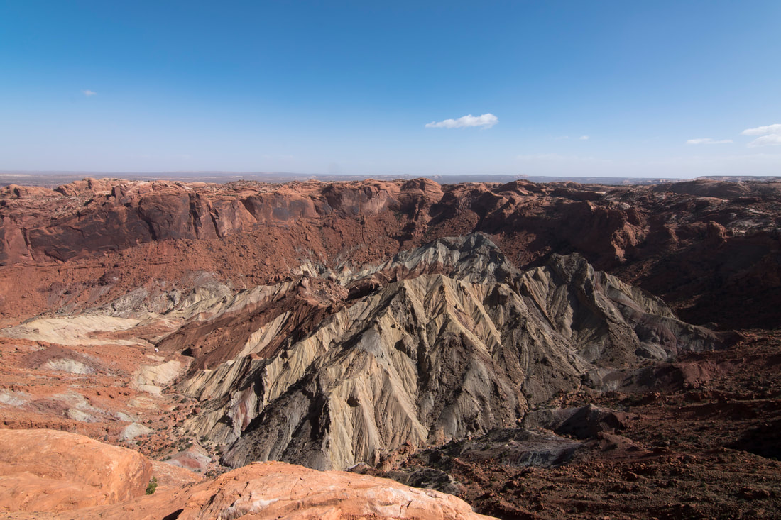 We say our goodbyes to Gavin and Liz today over some pancakes. They go on their way for one last ride in this landscape of sculpted sandstone. Lily and I pack up camp and head over to the Upheaval Dome Overlook to look down into the area that we had hiked the other day. A quick one mile hike and we gaze down into a crater where sand and dirt are piled high in an array of color. The walls are much the same as we gazed up at yesterday, tall, sheer and imposing. I can’t see where we hiked as the wall of the crater blocks that view. Unfortunately as well, the air quality is absolutely terrible today. The mountains that sit to both the west and the east are hardly visible. At this point in the trip I am ready to be away from the sheer cliff faces. Too many people doing things that make me nervous and the imposing majesty of it all has become overwhelming. I am ready for a nice wooded spot, preferably without any sheer drops nearby. Down the mesa we go, noting the very long line of cars at the one entrance into the park. I hope that the people near the end aren’t there for much more than three hours. Into Moab and the people are everywhere. We wonder if the weekend was in fact less busy. We grab our groceries and head out for a four hour drive towards a new place to camp and stay put for a couple of days. Along our drive we cross a portion of the land where great slabs of light gray stone rise hundreds of feet into the air. Deep canyons and twisting passages hide behind the wall of rock. The interstate goes right through it, a 5 mile stretch costing 4 million dollars where they blasted the rock away. We wind our way west and then turn north looking for some national forest in which to rest. We climb up through a canyon (more of a gentle space between two mountains than any of the canyons we had previously encountered) looking for a nice spot that I had spied on Google Earth. However, winter is reluctant to loosen her grip in these high altitudes. We encounter snow,ice, and a great deal of mud. The van has so far been good with most of what we throw at it but I’m not interested in seeing if we can get out of a spot with a steep muddy hill. So back down the mountain to below the snow and we park at a trailhead to an OHV track. As long as there isn’t too much noise here, we’ll probably stay put.
Not much happened today. We stayed here at the trailhead last night and will probably stay for another two nights as it seems quiet. Only a couple of OHV riders passed by today. Most of my time was spent editing photos, a chore that badly needed doing. We haven’t had time to just be with ourselves in a while so readjusting to that is a bit difficult. The afternoon is capped with a short hike up the hill by the river on the OHV trail and then a movie after dinner. This will be the second feature that has been shown in our cozy home.
Again in the woods. Our water is getting low but I think we should be able to make it. I work mostly on photos today.
The water lasted us through the morning (although it was gargling something fierce as we pulled up the dregs) and we make sure to grab water on our way to Salt Lake City. The drive is pretty as we pass small farms and small towns. The towns are like any other mountain west town. Victorian architecture thrown in with some slightly modern stuff, old barns and sheds crumbling away in the dry air. By midday, the small farms and town are gone as we enter the sprawling metropolis around Salt Lake City.   The Capitol is a palace. Outside, the grounds are circled by a path flanked by cherry blossom trees. We arrive at the perfect time to see them in bloom. All around the Capitol building the light pink petals fall softly as we admire the neo-renaissance architecture. Inside, the ceilings rise high up, arched with frosted glass in the ceiling to give diffused natural light. The center is reminiscent of a Catholic church with alcoves holding massive figurative statues representing such things as Immigration and Settlement and Land and Community. Filled with symbolic meaning, these figures are done in a renaissance style with flowing robes and soft but grand gestures. The dome sits high above the figures; blue sky with fluffy clouds and some birds in flight painted on it. Just beneath the dome there is a mural which circles the rotunda high above. It depicts various scenes across the history of Utah, many of which I don’t understand, such as “the seagulls save the wheat fields.” We learn that the Salt Lake valley was settled by the Mormons as they left the east, fleeing persecution, and finding a new home. Led by Brigham Young, the second president of the Church of Jesus Christ of Latter Day Saints (LDS), they set up their homesteads and built a city over the next several decades. Utah achieved statehood in 1896 after several attempts. The first attempts were rejected by congress because of how much influence the Mormon church had in the government. Plural marriages were not allowed in the Union and so that had to be struck from Utah's Constitution. Also, the Europeans who moved here wanted it to be known as the Deseret Territory and then State. Deseret is a word from the Mormon literature meaning honeybee, seen as representing industry. Congress decided to name the territory and state Utah, after the Ute tribe which had previously lived in much of this land. The Deseret idea still came through when Utah achieved statehood as the beehive is the state symbol and can be seen on the state flag and all of the state highway signs.
The smog cleared out today and we visit a small, local library to the west of downtown for blogging and taxes. We close out the library and go back to the Capitol for dinner and to see the sunset on the cherry blossoms. There are several young people still milling about after it gets dark with most of them dressed up in fancy gowns and suits. It seems as though the Capitol Building is being used for a prom
 Since parking is free downtown on Sundays, we spend the day in the downtown library to plan out our next leg of the trip. We think first we’ll head to Sacramento and then up the coast to see some of Lily’s family in Oregon and then up to Seattle to see Oliver and Carley. Sould be pretty easy to plan right? We close out the library six hours later. Again to the Capitol to make dinner and see the sunset among the beautiful cherry blossoms, and again to the same parking lot for a night of rest.
The morning is filled with the usual chores before we make our way out of Salt Lake City. Showers and one more quick trip to the library to download any media we may want on our computers (because for some reason we think we’ll actually make time to do that, hah). We head west, as those European descendants who settled this area did. The day is turning windy and gray as a large winter storm blows in. The wind blows us in all directions as it can’t seem to figure out which way to blow. We power down I-80, passing large mining operations. An old facility with large brick walls and several broken windows looms above the interstate. The large array of electrical components makes me wonder if this was an old power station. A little further along and a large tower appears from behind a hill. Slightly conical, the tapering tube is massive as we pass an industrial unit with the word “smelter”. Here is that industrious deseret ideal in action, eating up the earth and giving us energy and the precious metals that make our world go round. We briefly get a glimpse of the Salt Lake. It extends far to the north, ending at some unseen shore. As we pass over the cold desert, we see salt operations in the works. What looks to be white sand is laid up in large piles and poured into trucks. On the side of one building is the Morton logo, faded from the sun, of a person wearing large yellow boots and a yellow umbrella. Along the edges of the interstate I notice piles of rock pass by. As I pay more attention, I can just make out words and names before they whizz by. People use the flat and sandy areas on the side of the road to write messages with rocks. Hearts with initials, an endless stream of names, and other such decorations are left for miles along this stretch of highway. The endless desire of people to leave a mark on a place. As we get closer to the salt flats, I am surprised by a large creek. It runs clear, blue, and strong if the grass underneath is any indicator. I fully expected a land devoid of any moisture here, not this steady flow of water. We drive out a long stretch of asphalt and the brown dirt turns to white salt along the way. Much like in the Death Valley area, the dirt and salt mix, forming strange crusts that are broken up by the tire marks of someone driving out onto the desert. But the brown dirt turns to all white salt and the land gets impossibly flat as we arrive at the Bonneville Speedway. 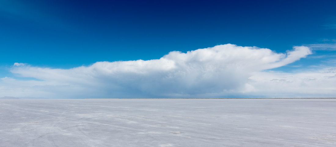 The day is stormy and it seems that we pull in just after a short storm. The sun shines on the salt, making it radiantly white while the storm clouds around us grow ominously dark. We spend a hot minute walking out onto the salt, taking in the flat landscape. There is a sign saying don’t drive on the salt if it’s wet, and I’m pretty sure it just rained here, so we don’t risk getting the van stuck today. The contrast between the storms around us and the brilliant white salt is spectacular. We take it in for the brief moment we have before the clouds come rolling in. With the sun disappearing, and the threat of rain, we move on to our camp spot out in the desert. We tuck ourselves into a nook in the Silver Mountains and get set up as wind rocks us back and forth and sheets of rain blow briefly down the mountains. The mountains are not much more than dark stone and dirt. Out in the valley, just before the salt, are rows of sagebrush and other desert shrubs. On the horizon, we can see the salt glow as the sun hits it between storms. A pure white band stretching across the horizon, giving a strange and definite boundary between the sky and the earth. We tuck in for the night in this harsh part of the world, readying ourselves to catch the first rays of sun on the salt flats in the morning. 
5 Comments
|
